
Northeast India (Northeast India)
Updated 2026The Eastern Himalayan Gateway & Cultural Crossroads of Eight Sister States
8
Sister States
200+
Major Tribes
220+
Languages
262,379 km²
Total Area
| Category | Detail |
|---|---|
| Altitude / Elevation | 40m to 8,586m (Kangchenjunga) |
| Best Time to Visit | October to May |
| Coordinates | 26.14° N, 91.74° E |
| Gateway Hub | Guwahati (GAU) & Bagdogra (IXB) |
| Highest Peak | Mount Kangchenjunga (8,586m) & Mount Kangto (7,090m) |
| ILP States | Arunachal Pradesh, Nagaland, Mizoram, Manipur (4 states require ILP) |
| States Count | 8 States (Assam, Meghalaya, Arunachal, Nagaland, Manipur, Mizoram, Tripura, Sikkim) |
| Total Area | 262,179 sq km (7.98% of India) |
Northeast India is a trans-Himalayan macro-region spanning eight distinct states across 262,179 square kilometers, bounded by Bhutan, Tibet, Myanmar, and Bangladesh. Ranging in altitude from 40 meters in the Brahmaputra floodplains to 8,586 meters at Kangchenjunga, it constitutes India’s premier biodiversity hotspot and indigenous cultural crossroads.
Dawn mist rises off the vast, braided currents of the Brahmaputra River, carrying the scent of damp alluvial loam and wild river grass. Across the northern horizon, the first rays of morning light turn the jagged, snowbound summits of the Eastern Himalayas from cold cobalt to burning gold, while from distant village monasteries and bamboo groves, the rhythmic resonance of prayer horns and morning temple drums drifts on the cool mountain air.
Inner Line Permit (ILP) is legally mandatory for domestic Indian citizens visiting Arunachal Pradesh, Nagaland, Mizoram, and Manipur. No ILP is required for Assam, Meghalaya, Sikkim (special local passes required for sensitive border zones like Nathu La/North Sikkim), or Tripura. Foreign tourists require Protected Area Permits (PAP) in Arunachal and designated frontier sectors.
Geography, Topography & Himalayan River Basins
North East India represents one of the most geographically diverse and ecologically significant frontiers on the Asian continent. Spanning 262,179 square kilometers—representing approximately 7.98% of India's total landmass—this trans-Himalayan region is connected to mainland India solely via the narrow, 22-kilometer-wide Siliguri Corridor (famously known as the Chicken's Neck) in northern West Bengal. The territory shares more than 5,182 kilometers of international borders (over 98% of its total perimeter) with five sovereign nations: Bhutan and Tibet (China) to the north, Myanmar to the east, and Bangladesh to the south and west.
The topography transitions dramatically across an extreme vertical relief of over 8,500 vertical meters. In the north and northwest, the high glaciated massifs of the Eastern Himalayas dominate Sikkim and Arunachal Pradesh, culminating in Mount Kangchenjunga (8,586 meters / 28,169 feet—the third-highest mountain on Earth) and Mount Kangto (7,090 meters). High-altitude mountain passes such as Sela Pass (4,170 meters), Bum La (4,633 meters), and Nathu La (4,310 meters) guard ancient trans-Himalayan trade routes.
South of the Himalayan arc lies the sprawling, alluvial Brahmaputra River Valley, a low-elevation corridor (40 to 100 meters above sea level) formed by the torrential Brahmaputra River (originating as the Yarlung Tsangpo in Tibet, traversing Arunachal as the Siang, and joined by the Lohit and Dibang rivers). To the south of the valley rises the ancient, geologically detached Meghalaya Plateau—comprising the Garo, Khasi, and Jaintia Hills—which ascends to 1,966 meters at Shillong Peak before plunging precipitously into the floodplains of Bangladesh. Forming the eastern and southeastern frontier are the rugged, jungle-covered ridges of the Purvanchal Range—encompassing the Patkai Range, the Barail Range, the Naga Hills (rising to Mount Saramati at 3,840 meters), the Manipur Hills, and the Lushai Hills of Mizoram.
The Eight Sister States & Distinct Cultural Territories
North East India is not a monolithic territory, but an extraordinary federation of eight autonomous states, each defined by distinct indigenous histories, linguistic roots, and social structures:
- Assam (Gateway to the Northeast): The economic and transportation engine of the region, centered around the fertile tea-growing plains of the Brahmaputra and Barak valleys. Famous for UNESCO World Heritage wildlife sanctuaries (Kaziranga and Manas), the sacred Shakti shrine of Kamakhya Temple, historic Ahom dynasty monuments in Sivasagar, and Majuli—the world's largest inhabited river island.
- Meghalaya (The Abode of Clouds): A high-altitude limestone and sandstone tableland celebrated for world-record rainfall at Mawsynram (11,872 mm annually) and Cherrapunji (11,777 mm). Home to the matrilineal Khasi, Jaintia, and Garo communities, who have engineered centuries-old living root bridges (Jingkieng Jri) across roaring canyon torrents.
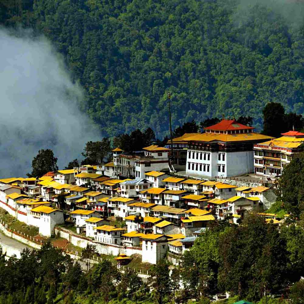
- Arunachal Pradesh (Land of the Dawn-Lit Mountains): India's largest northeastern state by area (83,743 sq km), characterized by deep river gorges, virgin subtropical rainforests, and high-altitude Tibetan Buddhist citadels, including the 17th-century Tawang Monastery (Galden Namgey Lhatse), alongside animist tribal cultures (Apatani, Nyishi, Adi, Mishmi, and Monpa).
- Nagaland (Land of Festivals): A mountainous frontier inhabited by 17 recognized Naga tribes, celebrated for warrior folklore, the world-famous annual Hornbill Festival at Kisama (December 1–10), the pristine high-altitude dwarf-bamboo landscapes of Dzukou Valley (2,452 meters), and Asia's first green conservation village at Khonoma.
- Manipur (The Jewel of India): Centered on the scenic Imphal Valley and the historic Kangla Fort, featuring Loktak Lake and the world's only floating national park (Keibul Lamjao), where the endangered brow-antlered Sangai deer thrives on buoyant biomass islands (Phumdis).
- Mizoram (Land of the Rolling Highlands): An orderly highland state known for community solidarity (Tlawmngaihna), sweeping bamboo-forested ridge towns, the pristine Blue Mountain (Phawngpui, 2,157 meters), and high literacy rates.
- Tripura (Heritage of the Manikya Kings): A historic kingdom characterized by rolling green hillocks, the magnificent Indo-Saracenic water palace of Neermahal on Rudrasagar Lake, Ujjayanta Palace in Agartala, and 7th-century rock carvings at Unakoti.
- Sikkim (The Himalayan Kingdom): Integrated as the eighth sister state in 2002, Sikkim is India's first 100% organic state, offering views of Mount Kangchenjunga, sacred glacial waters at Gurudongmar Lake (5,430 meters), and ancient Buddhist gompas (Rumtek, Pemayangtse, Enchey).
Biodiversity Hotspots, National Parks & The "Big Five"
North East India is globally recognized as one of the Earth's most critical biodiversity hotspots, situated at the unique zoogeographic intersection of the Indian, Indo-Malayan, and Indo-Chinese ecological sub-regions. Forest cover spans over 65% of the total land area, preserving exceptional endemism across flora and fauna:
- Kaziranga National Park (Assam): Inscribed as a UNESCO World Heritage Site in 1985, Kaziranga preserves 2,613+ Greater One-Horned Rhinoceroses (Rhinoceros unicornis)—more than 70% of the surviving global population. The park also harbors the world's densest breeding population of Royal Bengal Tigers, over 1,940 Asian elephants, 2,900+ wild water buffaloes, and the endemic Eastern swamp deer (barasingha).
- Manas National Park & Tiger Reserve (Assam): A UNESCO World Heritage Site and Biosphere Reserve contiguous with Bhutan's Royal Manas National Park, preserving critically endangered endemic species including the Pygmy Hog (Porcula salvania—the world's smallest wild suid), Golden Langur, Hispid Hare, and Bengal Florican.
- Khangchendzonga National Park (Sikkim): India's first and only UNESCO Mixed Heritage Site (inscribed 2016), protecting high-altitude Himalayan species including the Snow Leopard, Himalayan Red Panda, Musk Deer, and Blood Pheasant across 1,784 square kilometers of alpine glaciers and sacred Buddhist valleys.
- Keibul Lamjao National Park (Manipur): A 40-square-kilometer wetland sanctuary on Loktak Lake, celebrated as the only floating national park on Earth. The park protects the last wild population of the endangered Sangai Deer (Rucervus eldii eldii), which navigates the floating vegetative biomass (phumdis) with specially splayed hooves.
- Namdapha National Park (Arunachal Pradesh): Spanning altitudes from 200m to 4,571m in Changlang district, Namdapha is the only national park in the world harboring four wild feline species in the same habitat: Tiger, Leopard, Clouded Leopard, and Snow Leopard.
- Nokrek Biosphere Reserve (Meghalaya): Located in the West Garo Hills, Nokrek serves as the global gene sanctuary for Citrus indica (the primitive wild ancestor of all cultivated orange species) and preserves undisturbed populations of Western Hoolock Gibbons—India's only native ape species.
Seasonal Rhythm & Best Time to Visit
Because North East India spans elevations from 40 meters to 8,586 meters, weather patterns vary dramatically by altitude and seasonal wind systems:
- Peak Touring Season (October to April): The undisputed golden window for exploring all eight states. Skies are crisp and cobalt-blue, mountain visibility is exceptional, national parks open for wildlife safaris (Kaziranga and Manas operate strictly from November 1 to April 30 / May 31), and road connectivity across high passes is reliable. Autumn temperatures range between 12°C and 25°C in hill stations and 20°C to 30°C in river valleys.
- Crisp Winter & Snow Window (December to February): Days are bright, sunny, and invigorating, while nights become cold. High-altitude sectors—such as Tawang (3,048 meters), Sela Pass (4,170 meters), and North Sikkim (Yumthang / Lachung / Lachen)—receive heavy snowfall. Winter temperatures in high-altitude valleys frequently drop between -5°C and -15°C, requiring heavy thermal fleece and down parkas.
- Spring Bloom & Wild Orchids (March to May): Warmer weather (15°C to 28°C) brings the explosion of wild crimson and pink rhododendrons across the slopes of Sikkim, Arunachal, and Nagaland. Kaziranga's tall elephant grass is cut and burned by forest rangers in March, offering peak visibility for tiger and rhino tracking around shrinking water bodies.
- Monsoon Deluge (June to September): The Bay of Bengal monsoon brings torrential cloudbursts across the southern escarpments of Meghalaya (Mawsynram and Sohra receive up to 11,872 mm) and the Brahmaputra Valley. While Meghalaya's waterfalls surge with colossal water volumes, overland mountain road trips across Sikkim (NH10) and Arunachal Pradesh face serious landslide and mudslip hazards.
Transit Logistics, Aviation Gateways & Highway Corridors
Navigating North East India requires understanding the multimodal transport infrastructure connecting the plains with high mountain valleys:
- Primary Aviation Gateways:
- Guwahati Airport (Lokpriya Gopinath Bordoloi International Airport - GAU): The master aviation mega-hub of Northeast India, located 22 km west of Guwahati city center. Operating 24/7, GAU handles direct non-stop flights from New Delhi (2.5 hours), Mumbai (3 hours), Kolkata (1 hour), Bengaluru (3 hours), Hyderabad, and Chennai, alongside regional ATR feeder routes to all sister states.
- Bagdogra Airport (IXB): The primary air gateway for Sikkim and Darjeeling (120 km / 4.5 hours drive to Gangtok).
- State Aviation Gateways: Direct daily metro flights also serve Agartala (IXA) in Tripura, Imphal (IMF) in Manipur, Dimapur (DMU) in Nagaland, Dibrugarh (DIB) in Upper Assam, and the greenfield Donyi Polo Airport (HGI) in Itanagar, Arunachal Pradesh.
- Rail Corridors (Northeast Frontier Railway): Guwahati Railway Station (GHY) and Kamakhya Junction (KYQ) are the dual mega-railheads connecting the region with the rest of India via premier services including the Dibrugarh Rajdhani Express, New Jalpaiguri–Guwahati Vande Bharat Express, and Saraighat Express. Broad-gauge lines extend into Assam, Naharlagun (Arunachal), Dimapur (Nagaland), and Agartala (Tripura), with direct mountain rail lines nearing completion to Kohima (Zubza), Aizawl (Sairang), Imphal, and Sikkim (Rangpo).
- Arterial Highway Corridors:
- NH27 (East-West Expressway): A smooth 4-lane divided highway running east from West Bengal through Guwahati to Nagaon and Upper Assam.
- NH6: The lifeline highway climbing from Guwahati south to Shillong (100 km / 3 hours), continuing through Jowai into the Barak Valley (Silchar), Mizoram, and Tripura.
- NH13 (Trans-Arunachal Highway): Connecting 16 district headquarters across Arunachal Pradesh.
- NH29: The vital commercial highway linking Dimapur, Kohima, and Imphal.
- NH10: The scenic mountain highway linking Siliguri to Gangtok along the Teesta River gorge.
Local Food Culture & Indigenous Culinary Traditions
The food cultures of North East India are celebrated for their wholesome purity, reliance on fresh indigenous herbs, wood-smoked meats, and ancient fermentation techniques, without heavy commercial oils, dairy creams, or artificial food colorings:
- Assamese Food Culture: Subtle and refreshing, built around aromatic short-grain Joha rice, fresh river catch, and cold-pressed mustard oil. Signature preparations include Khar (an alkaline first-course delicacy filtered through charred banana peel ashes), Masor Tenga (a light sour fish curry soured with indigenous Kazi Nemu lemon or Thekera), and tender duck meat slow-cooked with ash gourd (Hahor Mangxo aru Kumura).
- Meghalayan Khasi & Jaintia Food Culture: Dominated by wood-smoked meats, earthy roasted black sesame seeds (Nei-iong), and fermented soybeans. Staples include Jadoh (red hill rice braised with meat stock and local ginger), Dohneiiong (slow-braised pork in a dark roasted black sesame paste), and spicy Tungrymbai.
- Naga Food Culture: Famed for intense wood smoking, deep fermentation, and the fiery kick of indigenous Raja Mircha (Bhut Jolokia / Ghost Pepper). Classic dishes include Smoked Pork with Axone (fermented soybean cakes), pork cooked with Anishi (smoked yam leaf cakes), and wholesome Galho (a comforting rice and seasonal forest green porridge).
- Arunachal Monpa & Tribal Specialties: A convergence of high-altitude Himalayan dishes (steamed Momos, hearty Thukpa noodle soups, and Puta buckwheat noodles tossed with fermented yak cheese Chhurpi) and central valley preparations featuring wild bamboo shoots (Ekung) and smoked river fish.
- Sikkimese Himalayan Traditions: Centered on fermented leafy greens (Gundruk), fermented soybeans (Kinema), slow-braised pork fat with radishes (Phagshapa), steamed dumplings, and ring-shaped crispy festive rice breads (Sel Roti).
- Manipuri Meitei Cuisine: Centered on fresh aromatic greens, aquatic herbs from Loktak Lake, and sun-dried fermented fish (Ngari), highlighted in wholesome stews like Kangshoi, spicy mashed salads like Eromba, and fragrant black glutinous rice pudding (Chak-hao Kheer).
- Mizo & Tripuri Staples: Mizo meals feature Bai (a light boiled stew of seasonal greens, bamboo shoots, and pork fat with wood-ash alkaline water) and Vawksa Rep (wood-smoked cured pork). Tripura's indigenous cuisine centers on Mui Borok, flavored with salt-free fermented small fish (Berma) and spicy Mosdeng chutneys.
Practical Travel Guide (The Honest Guide)
Traveling across North East India is an exhilarating expedition that demands grounded logistical planning and realistic expectations:
- Permit Rules & State Regulations (ILP Matrix):
- Inner Line Permit (ILP) Required for Domestic Indian Citizens (4 States): Arunachal Pradesh (
arunachalilp.com), Nagaland (ilp.nagaland.gov.in), Mizoram (ilp.mizoram.gov.in), and Manipur (manipurilponline.mn.gov.in). Domestic travelers must secure their e-ILP online 3 to 7 days in advance and keep 2 physical printed copies with government photo IDs handy for border checkposts. - Zero ILP Required (4 States): Assam, Meghalaya, Sikkim, and Tripura are 100% permit-free for domestic Indian tourists for general state entry. However, visiting sensitive international border sectors within Sikkim (such as Nathu La Pass, Tsomgo Lake, and North Sikkim / Gurudongmar Lake) requires special local Protected Area Passes arranged through registered local travel agents.
- Foreign National Regulations: Foreigners must secure Protected Area Permits (PAP) for Arunachal Pradesh (in groups of 2+ through authorized tour operators) and Restricted Area Permits (RAP) for Sikkim. Nagaland, Mizoram, and Manipur have relaxed PAP requirements, requiring foreign visitors only to complete e-FRRO registration within 24 hours of arrival. Assam, Meghalaya, and Tripura require only a standard Indian tourist visa.
- Inner Line Permit (ILP) Required for Domestic Indian Citizens (4 States): Arunachal Pradesh (
- Terrain Realities, Landslides & Drive Time Buffers: Mountain driving averages 25 to 35 km/h on winding single-lane hill roads. A 120-kilometer distance in Arunachal, Nagaland, or Sikkim typically requires 4.5 to 6 hours of driving. During the monsoon season (June to September), mudslides and rockfalls along corridors like NH10 (Siliguri to Gangtok) and NH6 (Meghalaya to Barak Valley) can cause multi-hour delays. Always maintain a 3-to-4 hour safety buffer when traveling to airport hubs on departure days.
- The Highland Cash Reality: While digital payments via UPI (Google Pay, PhonePe) work seamlessly in major gateway cities (Guwahati, Shillong, Gangtok, Dimapur, Agartala), cellular internet and digital UPI drop to zero in remote high-altitude valleys (North Sikkim, interior Arunachal, Dzukou Valley, Nongriat, and remote border villages). ATMs in small hill towns frequently run dry or suffer power outages. Always carry ₹5,000 to ₹10,000 in physical cash per person when heading beyond district capitals.
- Sunday Commercial Closures: In predominantly Christian tribal states (Nagaland, Meghalaya, Mizoram), commercial markets, private restaurants, auto-rickshaws, and public transport shut down completely on Sundays for religious worship and community rest. Ensure private chauffeured transport and hotel dining arrangements are pre-booked for Sunday travel.
- Cellular Connectivity Matrix: Jio and Airtel provide reliable 4G and 5G coverage throughout state capitals, national highway corridors, and major tourist centers. In remote frontier regions (such as Mechuka, Anini, Tuting in Arunachal, and Lachen/Lachung in North Sikkim), BSNL is frequently the sole operational network. Download offline Google Maps for all routes before departing airport hubs.
Northeast India has over 200 major tribes speaking 220+ languages — one of the most linguistically diverse regions on Earth.
TRAVEL PLANNING
Plan Your Visit
Essential guides to prepare for your trip
Itineraries & Trips
Curated 3-day, 5-day & 7-day trip routes
Places to Visit
Top waterfalls, viewpoints & landmarks
Best Time to Visit
When to go for the best experience
How to Reach
Flights, trains, taxis and road options
Where to Stay
Homestays, eco-lodges & resorts
Permits & Entry
Required documents and ILP pass guidance
Need a Custom Plan?
Our local experts in Northeast India can create a personalized itinerary just for you.
Talk to an ExpertTOP ATTRACTIONS
Places to Visit in Northeast India
Must-see attractions and hidden gems across Northeast India
How Many Days in Northeast India?
Plan your own route — or let us handle everything
Things to Do in Northeast India
Curated experiences and activities across Northeast India by local experts
Where to Stay in Northeast India
Verified stays in Northeast India with local character
Getting Around
Safe, reliable transfers and car hire in Northeast India
Combine Northeast India With
Extend your trip with nearby destinations
Travel Guides
Expert guides for Northeast India
Reviews
"Our 10-day Assam-Meghalaya trip was perfectly planned by Nezo. Kaziranga, Cherrapunji, and Dawki — every day was a new adventure."
Priyanka Chopra
Bangalore, India
"I've traveled to 40 countries and Northeast India is among the most beautiful regions I've seen. Nezo's multi-state coordination was flawless."
John Anderson
New York, USA
"The Hornbill Festival was on my bucket list. Nezo arranged our entire Nagaland + Assam trip. The ILP process was handled seamlessly."
Sana Mirza
Hyderabad, India
PLAN YOUR TRIP
FAQs
Can't find the answer you're looking for? Our expert travel team is always on hand to help you plan the perfect Northeast India experience.
Ready to Explore Northeast India?
Let our local experts help you plan the perfect trip. Get personalized recommendations and instant quotes.