
Arunachal Pradesh (Land of the Dawn-Lit Mountains)
Updated 2026The Land of the Dawn-Lit Mountains & Eastern Himalayan Citadels
| Category | Detail |
|---|---|
| All Weather Tunnel | Sela Tunnel (Twin-tube, 13,000 ft altitude, operational March 2024) |
| Altitude / Elevation | 100 m (Foothills) to 7,090 m (Kangto Peak / Gorichen Massif) |
| Best Time to Visit | October to April (Autumn clarity, winter snow, and spring rhododendron bloom) |
| Capital | Itanagar (Papum Pare District, 350 m altitude) |
| Five River Basins | Kameng, Subansiri, Siang (Brahmaputra), Dibang, and Lohit |
| Major Circuits | Western Circuit (Tawang/Dirang), Central Circuit (Ziro/Aalo/Pasighat), Eastern Circuit (Roing/Namdapha/Dong) |
| Major Passes | Sela Pass (4,170 m), Bum La Pass (4,633 m), Mayodia Pass (2,655 m) |
| Major Tribes | 26 Major Tribes & 100+ Sub-Tribes (Monpa, Apatani, Nyishi, Adi, Mishmi, Singpho, Wancho) |
| Permit Requirement | Inner Line Permit (ILP) mandatory for all domestic Indian citizens; Protected Area Permit (PAP) for foreign nationals |
| Total Area | 83,743 sq km (Largest state in Northeast India) |
Arunachal Pradesh is India's easternmost frontier state, spanning 83,743 square kilometers of the Eastern Himalayas between Bhutan, Tibet, and Myanmar. Ranging in elevation from 100 meters in the subtropical Assam foothill plains to 7,090 meters at Kangto Peak, the state is home to 26 major indigenous tribes, the 346-year-old Tawang Monastery (India's largest Buddhist citadel), the UNESCO-tentative agricultural landscape of Ziro Valley, the turbulent rapids of the Siang River, and the biodiverse rainforests of Namdapha National Park.
The first rays of sunlight anywhere in India strike the icy summits of Dong Valley and Sela Pass, turning vast snowfields from cold amethyst to brilliant crimson gold. Through the crisp mountain air at 10,000 feet, the deep resonance of long copper dungchen horns and Tibetan prayer chants drifts down from the whitewashed walls of Tawang Monastery, mingling with the scent of burning juniper incense, butter lamps, and wild pine resins across deep river gorges.
Inner Line Permit (ILP) is legally mandatory for all domestic Indian non-residents under the Bengal Eastern Frontier Regulation 1873. Apply online at eilp.arunachal.gov.in or arunachalilp.com (fee: ₹300 up to 3 days, ₹500 beyond 3 days up to 14 days). Foreign nationals require a Protected Area Permit (PAP) issued under Ministry of Home Affairs regulations (US$50 fee, minimum group size of 2 persons, applied via registered tour operators or DRC Office Guwahati / RC Office New Delhi). Indian citizens visiting border sectors such as Bum La Pass (4,633 m) or Madhuri Lake must obtain local civil/military NOC passes in Tawang.
Trans-Himalayan Orography, River Basins & Extreme Altitudes (100 m to 7,090 m)
Arunachal Pradesh, aptly christened the 'Land of the Dawn-Lit Mountains', is the largest state in Northeast India, covering 83,743 square kilometers of complex Eastern Himalayan terrain. Bounded by international frontiers with the Tibet Autonomous Region of China to the north and northeast (1,129 km), Myanmar to the east (520 km), and Bhutan to the west (217 km), the state constitutes one of the most rugged and strategically significant geographical frontiers in Asia. The topography encompasses an extraordinary vertical matrix ascending from the subtropical alluvial plains of the Assam border at 100 meters above sea level to towering, permanently glaciated Himalayan spires culminating at Mount Kangto (7,090 m) and the Gorichen Massif (6,488 m).
The drainage system of Arunachal Pradesh is carved by five colossal river valleys, each draining the snowfields of the Tibetan plateau southward into the Brahmaputra River:
- The Kameng Basin (West): Flowing past Bhalukpong, Bomdila, and Seppa through dense subtropical and temperate rainforests.
- The Subansiri Basin (Central-West): Rushing through steep gorges across Upper and Lower Subansiri districts past Daporijo.
- The Siang Basin (Central): The colossal Yarlung Tsangpo river entering India from Tibet through deep trans-Himalayan gorges at Gelling and Tuting, flowing past Yingkiong and Pasighat where it enters the Assam plains to become the Brahmaputra.
- The Dibang Basin (Central-East): Draining the high alpine snowfields of the Mishmi Hills through Roing and Anini.
- The Lohit Basin (East): Flowing past Tezu, Parasuram Kund, and Hayuliang, originating in eastern Tibet.
The Mosaic of Twenty-Six Major Tribes & Cultural Zones
Arunachal Pradesh is home to 26 major indigenous tribes and more than 100 sub-tribes, presenting one of the richest anthropological tapestries on Earth. The state’s tribal communities are broadly divided into three distinct ethno-cultural and spiritual traditions:
- Western Mahayana Buddhist Realm: In the western high districts of West Kameng and Tawang, the Monpa and Sherdukpen tribes practice Tibetan Mahayana Buddhism (Gelugpa and Nyingma traditions). Their culture centers around whitewashed mountain chortens, mani prayer wheels, and grand monastic citadels.
- Central Donyi-Polo Animist Realm: Across central and eastern districts, the Apatani, Nyishi, Adi (including Minyong, Padam, and Gallong), Tagin, and Mishmi tribes practice ancestral Donyi-Polo (reverence for the Sun and Moon as cosmic creator deities). Their material culture is characterized by monumental bamboo architecture, sacred sacrificial altars (Yugyang), cane suspension bridges, and vibrant agricultural harvest festivals like Nyokum (Nyishi, February), Myoko (Apatani, March), and Solung (Adi, September).
- Eastern Theravada & Animist Realm: In the eastern districts of Namsai, Changlang, and Tirap, the Tai Khamti and Singpho tribes practice Theravada Buddhism, living alongside the Wancho and Nocte communities who are celebrated for intricate ancestral woodcarvings and traditional beadwork.
The Western Buddhist Circuit: Monpa Heritage, Sela Pass & 1681 Tawang Monastery
The Western Circuit is the most renowned travel corridor in Arunachal Pradesh, winding along the Balipara–Charduar–Tawang (BCT) mountain highway:
- Bhalukpong & Tippi (213 m): Entry gateway along the Kameng River, famous for the Tippi Orchid Research Centre, housing over 500 species of rare Eastern Himalayan orchids.
- Bomdila (2,415 m): The administrative heart of West Kameng, offering panoramic views of Kangto Peak, apple orchards, and the serene Gentse Gaden Rabgyel Lling Monastery.
- Dirang Valley (1,497 m): A picturesque temperate river valley along the Kameng River, famous for 500-year-old stone architecture at Dirang Dzong, natural hot springs, and the high-altitude kiwi orchards of Sangti Valley (a winter roosting sanctuary for the endangered Black-Necked Crane).
- Sela Pass (4,170 m / 13,700 ft) & Sela Lake: The dramatic high-altitude mountain gateway to Tawang, framed by jagged snow peaks, prayer flags, and deep winter snowdrifts.
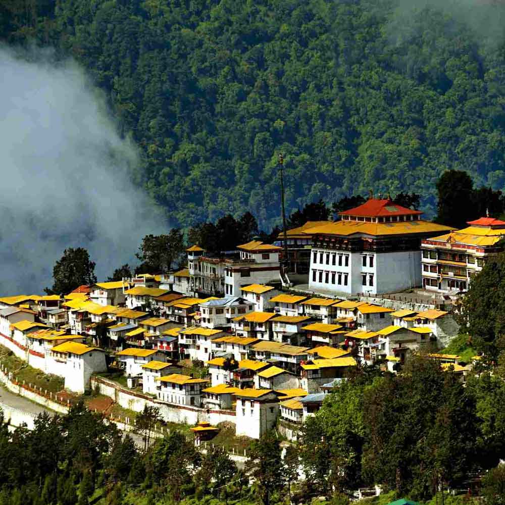
- Tawang Monastery (Galden Namgey Lhatse, 3,048 m): Founded in 1680–1681 A.D. by Merak Lama Lodre Gyatso under the authority of the 5th Dalai Lama, Tawang Monastery is the largest Buddhist monastery in India and the second-largest on Earth (after the Potala Palace in Lhasa). Perched like a medieval fortress at 10,000 feet, the citadel houses over 400 monks, an invaluable library of ancient gold-lettered Buddhist scriptures (Kangyur), and a monumental 26-foot gilded statue of Buddha.
- Bum La Pass (4,633 m / 15,200 ft) & Sangestar Tso (Madhuri Lake): Perched along the McMahon Line on the Indo-Tibetan frontier, Bum La was the historic route of the 1962 Sino-Indian War and the escape path of the 14th Dalai Lama into India in 1959. Nearby Sangestar Tso, formed by a 1950 earthquake, features surreal dead pine tree trunks rising from clear glacier waters.
The Central Animist Heartland: Apatani Wet-Paddy Systems & Donyi-Polo Traditions
In the central high valley of Lower Subansiri District at an altitude of 1,500 meters, Ziro Valley is an internationally acclaimed cultural and agricultural sanctuary:
- UNESCO-Tentative Apatani Agriculture: The Apatani people have perfected a closed-loop, sustainable agro-ecosystem without modern machinery. Their flat valley floor is divided into terraced wet-paddy fields (Aji) irrigated by mountain stream channels, where rice cultivation is integrated with freshwater fish farming (Ngi), bordered by cultivated groves of tall blue pine (Pinus wallichiana) and timber bamboo (Phyllostachys bambusoides).
- Facial Tattoos & Yaping Hullo: The older generation of Apatani women are celebrated for their ancestral black facial line tattoos (Tiipe) and large dark bamboo nose plugs (Yaping Hullo), a historic customary practice unique to the valley.
- The Ziro Festival of Music: Held every September amidst golden paddy terraces, this world-renowned outdoor indie music festival brings international artists together with indigenous folk traditions in a zero-waste, bamboo-built venue.
The Eastern Frontier & Pristine Rainforests: Namdapha Biosphere to Dong Valley
The eastern frontier of Arunachal Pradesh preserves some of the last vast, contiguous primary wildernesses in Asia:
- Namdapha National Park & Tiger Reserve (1,985 sq km): Located in Changlang District, Namdapha is the fourth-largest national park in India. Spanning an extreme altitudinal range from 200 meters to 4,571 meters at Daphabum Peak, it is the only national park in the world harboring four sympatric feline apex predators: the Royal Bengal Tiger, Common Leopard, Clouded Leopard, and the high-altitude Snow Leopard. The dense evergreen dipterocarp rainforest is also a prime habitat for the endangered Hoolock Gibbon and the critically endangered Namdapha Flying Squirrel.
- Dong Valley & Kaho (Lohit District): The easternmost inhabited village in India, where the first sunrise on Indian soil breaks each morning at 04:30 AM over the snowy summits of the Walong battleground.
Engineering Milestones: The Sela Tunnel & Trans-Arunachal Highway (NH13)
Infrastructure in Arunachal Pradesh has undergone a historic revolution with the completion of landmark engineering projects:
- The Sela Tunnel Project (Inaugurated March 2024): Constructed by the Border Roads Organisation (BRO) at an altitude above 13,000 feet, the Sela Tunnel is the longest bi-lane highway tunnel in the world constructed at an elevation above 13,000 feet. Comprising a 1.59 km main twin-tube tunnel and an 8.6 km approach network, it bypasses the treacherous, avalanche-prone 13,700 ft Sela Pass summit, guaranteeing 365-day all-weather vehicular connectivity to Tawang and reducing travel time by 60 to 90 minutes.
- Trans-Arunachal Highway (NH13): A 1,559 km spinal two-lane highway connecting 16 district headquarters across the state from Tawang in the west to Kanubari in the east, dramatically opening interior tribal valleys to sustainable tourism.
Mountain Sustenance: Monpa Staples, Wild Forest Foraging & Apong Brews
The traditional food culture of Arunachal Pradesh is defined by organic highland agriculture, forest foraging, and natural fermentation without commercial oils or powdered spices:
- Monpa Tibetan Staples: Hand-pulled wheat noodle soups (Thukpa), delicate steamed dumplings (Momos), and Zan (a slow-cooked roasted barley or finger millet porridge eaten with fermented yak milk cheese, Churpi).
- Chamin Condiment: Fermented yak milk cheese stewed with roasted bird's-eye chillies and wild mountain herbs.
- Lukter & Smoked Meats: Thinly sliced beef, pork, or mountain goat meat smoked over hearth embers, pounded with fiery dried king chillies and local Sichuan pepper (Rikho).
- Pika Pila: A traditional Apatani pickle prepared from pork lard, bamboo shoots, and dried chillies.
- Apong / Marua: Traditional fermented beer brewed from roasted rice or finger millet, filtered through conical bamboo sieves and served cool in hollow bamboo tumblers.
Strict Regulatory Regime: Mandatory e-ILP, Protected Area Permits (PAP) & Border Protocol
Due to its sensitive international frontier status, travel within Arunachal Pradesh is strictly regulated:
- Domestic Indian Citizens — Inner Line Permit (ILP): Mandatory for all non-resident Indian citizens under the Bengal Eastern Frontier Regulation 1873. Applied online via
eilp.arunachal.gov.inorarunachalilp.com(fee: ₹300 up to 3 days, ₹500 beyond 3 days up to 14 days). Printouts must be presented at border check gates (Bhalukpong, Pasighat, Gumto, and Namsai). - Foreign Nationals — Protected Area Permit (PAP): Foreign tourists must obtain a Protected Area Permit issued by the Ministry of Home Affairs (US$50 fee, minimum group size of 2 persons). The PAP is typically arranged via accredited tour operators or applied in person at the Deputy Resident Commissioner Office in Guwahati or Resident Commissioner Office in New Delhi.
- Bum La Pass Military Clearances: Indian citizens visiting high-altitude frontier passes (Bum La Pass, Madhuri Lake) require an NOC from the DC Office in Tawang, stamped and countersigned at the Indian Army Brigade Headquarters. Foreign passport holders are strictly prohibited from visiting Bum La Pass.
Practical Frontier Intelligence: Road Realities, Acclimatization & Seasonality
- Optimal Travel Seasons: The ideal window is October to April. Autumn (October–November) offers clear skies; winter (December–February) brings heavy snow to high passes; spring (March–April) brings mild weather with blooming orchids and rhododendrons. Avoid the high monsoon (June–September) due to landslides.
- High-Altitude Acclimatization: When traveling to Tawang (3,048 m), spend at least one night at intermediate elevations in Dirang (1,497 m) or Bomdila (2,415 m) to acclimatize and prevent Acute Mountain Sickness (AMS).
- 4x4 Vehicles & Daylight Driving: Mountain road journeys average 25–35 km/h. Hire robust high-ground-clearance 4x4 vehicles (Mahindra Scorpio, Bolero, Toyota Innova Crysta) with experienced local drivers and avoid mountain driving after sunset.
Arunachal Pradesh, with 26 major tribes and 50+ languages, is the first place in India to see the sunrise each day.
TRAVEL PLANNING
Plan Your Visit
Essential guides to prepare for your trip
Itineraries & Trips
Curated 3-day, 5-day & 7-day trip routes
Places to Visit
Top waterfalls, viewpoints & landmarks
Best Time to Visit
When to go for the best experience
How to Reach
Flights, trains, taxis and road options
Where to Stay
Homestays, eco-lodges & resorts
Permits & Entry
Required documents and ILP pass guidance
Arunachal Pradesh Tour Packages
Ready-to-book Arunachal Pradesh tours


Need a Custom Plan?
As Northeast India locals, we work directly with our trusted community drivers and homestay hosts.
Talk to an ExpertTOP ATTRACTIONS
Places to Visit in Arunachal Pradesh
Must-see attractions and hidden gems across Arunachal Pradesh



- Buddha Heritage Park: A majestic golden Buddha statue in a peaceful mountain park
- Zengbu Gompa: Ancient hilltop sanctuary of the Sherdukpen tribe
- Shergaon State Horticulture Farm: Arunachal's premier temperate orchard and trout breeding station
- Orchid Research Centre, Tippi: Exploring Asia's premier orchid sanctuary and tissue culture research hub on the Kameng River
How Many Days in Arunachal Pradesh?
Plan your own route — or let us handle everything
Things to Do in Arunachal Pradesh
Curated experiences and activities across Arunachal Pradesh by local experts
Where to Stay in Arunachal Pradesh
Verified stays in Arunachal Pradesh with local character


Getting Around
Safe, reliable transfers and car hire in Arunachal Pradesh
Practical Travel Realities & Local Tips
Terrain, ground rules, and essential preparation for Arunachal Pradesh
Arunachal Pradesh is rated a Moderate to Challenging travel destination. The rewards of untouched Himalayan landscapes and authentic tribal heritage require proper physical and logistical preparation:
- High Altitude & Acclimatization: Key destinations sit at high elevations—Tawang at 3,048 meters (10,000 ft), Sela Pass at 4,170 meters (13,700 ft), and Bum La Pass at 4,633 meters (15,200 ft). To prevent Acute Mountain Sickness (AMS), all itineraries must include an acclimatization overnight stay at mid-altitude in Dirang (1,497 m) or Bomdila (2,415 m) before ascending to Tawang.
- Long Mountain Driving Days: Transit in Arunachal is measured in driving hours rather than kilometers. Average mountain speeds hover between 25 and 35 km/h on winding ghat roads with sharp hairpin bends. Motion sickness medication is strongly recommended.
- Remote Infrastructure: While major towns have modern hotels, remote valleys rely on traditional homestays with basic heating and wood-fired water heating. Power cuts occur during mountain storms; carrying reliable power banks is essential.
- Sub-Zero Winter Weather: High-altitude winter visits require serious cold-weather layering rated for temperatures down to -10°C.
Local Culinary Traditions & Food
Authentic indigenous gastronomy, tribal flavours, and culinary culture in Arunachal Pradesh
The traditional food culture of Arunachal Pradesh reflects its rich tribal diversity, organic Himalayan agriculture, and sustainable forest foraging. Cooking methods rely on boiling, steaming, smoking, and fermenting, with zero artificial coloring or heavy refined oils:
- Thukpa & Handmade Momos: Ubiquitous across the Monpa heartland of Tawang and Dirang. Steaming bowls of hand-pulled wheat noodles served in fragrant bone broths with wild mountain greens, paired with delicate steamed dumplings filled with spiced meat or local cabbage and curd.
- Zan: A traditional Monpa staple prepared from roasted finger-millet or buckwheat flour, slow-simmered into a thick porridge and savored alongside dried-meat broths and fermented yak cheese.
- Churpi & Chamin: Fermented yak milk cheese produced in high-altitude pastures. Soft Churpi is cooked with fierce king chillies into a pungent, warming gravy called *Chamin*, while hardened Churpi is chewed as a protein-rich alpine snack.
- Lukter: A fiery indigenous preparation of shredded sun-dried or smoked beef, pork, or mithun meat pounded violently with roasted Bhut Jolokia (Ghost Pepper) and wild mountain herbs.
- Fermented Bamboo Shoots (Ekung & Eup): Grated and fermented bamboo shoot pulp (*Ekung*) and sun-dried bamboo strips (*Eup*) form the sour, umami foundation of tribal pork and fresh river fish curries across the Nyishi, Adi, and Apatani communities.
- Pasa (Adi Raw Fish Herbal Broth): A ceremonial Adi delicacy made by finely mincing fresh river fish and blending it with raw extracts of wild medicinal jungle herbs (*Onger* leaves, *Phrynium* roots), ginger, and mountain spices.
- Apong & Opo (Traditional Rice Beer): Organic fermented rice and millet brew prepared using indigenous yeast cakes (*Pitha*) and filtered through woven cane baskets into bamboo mugs—a central symbol of tribal hospitality.
Dietary Guidance: While traditional tribal cooking revolves around fresh meats, fish, and forest greens, standard North Indian vegetarian and Jain meals are readily available in hotels and restaurants across all major transit towns.
Combine Arunachal Pradesh With
Extend your trip with nearby destinations
Travel Guides
Expert guides for Arunachal Pradesh
Reviews
"Service was excellent. Prices were the best compared to those offered by others. All in all a satisfying experience. Definitely recommended."
Pradeep Agarwal
Delhi, India
"Arunachal is India's best-kept secret. Nezo organized our Ziro Valley visit where we met the Apatani tribe. The rice-fish cultivation system is ingenious."
Lhamo Yangzom
Kolkata, West Bengal
"The biodiversity of Arunachal is astounding. Namdapha National Park is a must for wildlife enthusiasts. Nezo's local knowledge made the trip exceptional."
James O'Brien
Dublin, Ireland
PLAN YOUR TRIP
FAQs
Can't find the answer you're looking for? Our expert travel team is always on hand to help you plan the perfect Arunachal Pradesh experience.
Ready to Explore Arunachal Pradesh?
Let our local experts help you plan the perfect trip. Get personalized recommendations and instant quotes.