
Bamboo Trek in Mawryngkhang
"Climb the legendary King of Stones along a handcrafted Khasi bamboo cliff path suspended over the Umrew River gorge."
The Mawryngkhang Bamboo Trek (Jingkieng Mawryngkhang) is a 3.5 km cliff-edge trail in Wahkhen Village, East Khasi Hills, Meghalaya. Suspended over the Umrew River gorge using vernacular bamboo bridges built in 2016, the route ascends 268 meters of vertical relief to summit a 100-meter sacred monolith known as the King of Stones.
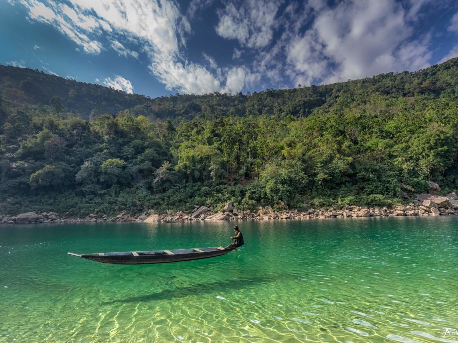
Stiff green bamboo groans softly underfoot as mountain wind cuts across the open abyss of the Umrew River gorge. Below, turquoise rapids thunder against smooth sandstone boulders, sending a cool, mineral spray up vertical cliff faces. On the Mawryngkhang Bamboo Trek, every step along the narrow cane-tied rungs demands total balance and intense focus.
The Legend of the King of Stones
In local Khasi folklore, stones possess life, spirit, and ancestral lineage. Prominent among them stands U Mawryngkhang (U being the masculine Khasi prefix, translating directly to the 'King of Stones'), revered as the supreme stone lord across the southern river valleys of the Khasi Hills. Standing immediately behind him is Ka Kthiang, a slender, graceful stone pinnacle (Ka being the feminine prefix) embodying the maiden who captured Mawryngkhang's heart.
Their peace was shattered when U Mawpator, a fierce rival stone lord from a neighboring river basin, sought Ka Kthiang's hand by force. An epic duel erupted across the canyon. During the struggle, Mawpator struck Mawryngkhang on his left shoulder, slicing off his left arm. That wound remains visible today as a deep, angular cleft scar on the rock's northern face. Mawryngkhang answered with a decisive strike, severing Mawpator's head; the massive rounded boulder representing Mawpator's decapitated head lies marooned in the gorge of the Wah Umrew (Umrew River; frequently misspelled as 'Wahrew' in outside travel accounts). Two intermediate geological waypoints mark the battlefield: Mawmoit, the high ridge perch where Ka Kthiang stood watching the duel, and Mawkhlieng, a dizzying ledge known as the eagle's roost.
Vernacular Engineering: The Living Bamboo Architecture
Modern infrastructure in remote mountain valleys often relies on heavy concrete footings and steel girders that destabilize fractured shale slopes. In 2016, the youth and village elders of Wahkhen chose a different path under the leadership of their Dorbar Shnong (traditional village council) and the Wahkhen Tourism Society. Without external government funding or heavy industrial machinery, the village hand-built a suspended pathway running along the vertical river walls.
The entire structure relies on indigenous materials sourced from the surrounding forests. Giant hill bamboo poles (Tyndai) form horizontal deck walkways, fastened with iri—a remarkably tough, pliable wild mountain cane cord that tightens as it dries. To anchor walkway spans across sheer sandstone and limestone cliffs, builders hammered seasoned hardwood wedges and steel reinforcement pins into natural rock fissures. From these anchors, they cantilevered horizontal scaffolds across chasms dropping 100 to 300+ feet straight down into the Umrew River. Minimal industrial nails are used solely to lock critical high-stress structural joints. The Dorbar Shnong inspects the trail year-round, rotating maintenance squads every six to twelve months to replace weathered bamboo stems before structural integrity degrades.
Trail Anatomy: From Wahkhen to the Monolith Summit
The journey begins at the Wahkhen trailhead parking area at an elevation of 900 meters. From the village boundary, the trail descends steeply through broom-grass plantations along hand-hewn stone steps, dropping 250 meters into the humid canyon floor of the Umrew River at roughly 650 meters elevation. The core round-trip trail covers 3.5 km (approximately 5 km including village approach trails) and requires 3 to 5 hours of demanding hiking.
At the river basin, trekkers step onto the first major test: a suspended bamboo bridge spanning the rushing torrent of the Umrew River. Here, crystalline water cascades between polished sandstone monoliths into luminous turquoise pools. Once across the river, the path shifts from a ground trek into an aerial cliff walk.
Pinning itself against the vertical wall of Mawkhlieng Cliff, the walkway narrows to three or four parallel bamboo poles lashed side-by-side, bordered only by a waist-high bamboo handrail. Hikers negotiate cantilevered turns where the rock drops away into empty space below their boots. After pausing at the Mawmoit viewpoint platform, the route dips down a ravine before commencing the final assault on U Mawryngkhang. Trekkers ascend a succession of nearly vertical bamboo ladders and notched timber stairs lashed directly onto the curved, unyielding flank of the rock dome. The route tops out on the broad crest of the 100-meter high monolith at an altitude of approximately 800 to 850 meters, offering unhindered panoramas across the gorge ridges and south toward the sweeping plains of Bangladesh.
The Musical Soul of Wahkhen Village
Wahkhen is distinguished not only by its engineering daring, but also as one of the premier cultural sanctuaries of the Khasi Hills. In 2002, village elders and passionate musicians established the Sieng Riti Institute, an autonomous rural academy committed to keeping ancient Khasi musical traditions and instrument fabrication alive.
Within the village, craftspeople hand-carve and teach youth to play traditional instruments: the Tangmuri (a double-reed wooden folk shawm essential to Khasi ceremonial dances), the Duitara (a four-stringed wooden lute plucked with horn or bone), the Ka Bom (a resonant bass drum hollowed from solid timber), and the Besli (a transverse bamboo flute). Wahkhen is also celebrated for maintaining Jingrwai Iawbei, an ancient matrilineal tradition wherein mothers bestow a unique musical tune or whistling melody upon each newborn child. Throughout their lives, villagers address, summon, and greet one another across steep agricultural valleys using these personal whistling signatures.
What NOT to Expect (Ground Realities)
Do not expect a commercialized tourist park with concrete walkways, handrail cages, or emergency rescue infrastructure. Mawryngkhang is a raw, community-crafted cliff route designed for confident hikers:
- No Safety Harnesses or Protective Netting: You walk on bare bamboo stems cantilevered over 100 to 300+ foot drops. There are no harness cables or catch-nets. If you experience acrophobia, panic on narrow ledges, or suffer from knee instability, you should not hike this trail.
- Zero Mobile Connectivity: Cellular network drops to zero immediately upon descending into the Umrew River canyon. Download offline navigation routes before leaving Shillong.
- No Motorized or Mechanized Evacuation: In the event of injury or exhaustion, emergency evacuation is manual on foot, carried by village volunteers up 268 meters of steep stairs.
- No Concessions in the Gorge: There are no food stalls, drinking water sources, or restrooms once you cross the river bridge. All supplies must be carried from Wahkhen Village, and all waste must be packed out.
Photography Guide & Strategic Vantage Points
Photographing the Mawryngkhang trail demands steady footing, secure gear straps, and an understanding of canyon light:
- The Umrew River Suspension Bridge: Shoot looking north-northeast from the riverbed boulders to frame the bamboo walkway ascending the sheer vertical rise of Mawkhlieng Cliff. Early morning light (07:30 to 09:30 AM) provides balanced exposure without harsh cliffside shadows.
- Mawmoit Viewpoint Perch: The staging platform at Mawmoit provides the definitive wide-angle perspective capturing the slender pinnacle of Ka Kthiang standing behind the massive rounded crown of U Mawryngkhang.
- The Final Monolith Ladder: Position yourself at the base of the rock dome to shoot upward as trekkers navigate the near-vertical bamboo ladders pinned directly to the stone face.
- Gear Security & Drone Policy: Secure cameras and smartphones with heavy-duty wrist or neck lanyards. Dropping a device between bamboo rungs means permanent loss in the boulder riverbed below. Commercial drone flights require prior clearance and fee payment at the Wahkhen Tourism Society desk.
Seasonal Conditions & River Dynamics
- Winter & Post-Monsoon (October to April): The premier window for Mawryngkhang. Daytime temperatures range comfortably between 16°C and 22°C, the bamboo is dry with reliable shoe grip, and the Umrew River settles into crystalline turquoise pools suitable for resting near the base.
- Pre-Monsoon Humidity (April to May): High humidity builds inside the canyon basin. Begin hiking by 07:30 AM to complete the return ascent before the midday sun hits the exposed rock faces.
- Monsoon Closure & Risks (June to September): Heavy monsoon downpours turn bamboo nodes dangerously slick with moss and cause flash floods along the Umrew River. The Dorbar Shnong periodically closes the trail during heavy rain alerts; trekking during active torrential storms is unsafe.
Route Planning and Regional Connections
Wahkhen is located in the Pynursla C&RD Block, 48 km south of Shillong. As Northeast India locals, we recommend leaving Shillong early in the morning along NH206 (the Shillong-Dawki road). Pass through Mylliem and proceed past Pomlum junction, where you turn off the highway onto a 15 km single-lane paved rural road that winds down through high ridges into Wahkhen. The drive takes between 2 and 2.5 hours.
Wahkhen integrates smoothly into broader southern Meghalaya itineraries. It sits 50 km from Cherrapunji (Sohra) via the Laitryngew bypass route and 38 km north of the river border town of Dawki. Travelers planning regional itineraries can consult our Shillong destination guide or include Wahkhen as an active cliff-trekking highlight within a 7-day tour package exploring southern Meghalaya.
Insider Tips
- Hire an authorized local guide from Wahkhen Village (₹500–₹800); their fee directly supports the village tourism society and their spotting helps you navigate shaky bamboo rungs safely.
- Wear sticky-soled, closed-toe trail shoes or hiking boots with deep rubber lugs; smooth sneakers, flip-flops, and street shoes slip dangerously on wet bamboo nodes.
- Begin the hike before 8:30 AM; descending into the canyon early avoids the punishing midday sun on exposed ladders and ensures you clear the 1:00 PM trail entry cutoff.
- Carry at least 2 liters of water and electrolyte packs; the return climb demands an uphill gain of 268 meters out of the hot gorge floor.
- Keep both hands free by using a compact backpack; never attempt to hold an unstrapped smartphone or camera while traversing ladder sections.
- Pack complete cash reserves for entry fees, parking, guide fees, and roadside tea stalls; there is no ATM in Wahkhen or along the 15 km approach road from Pomlum.
- Download offline topographic maps before leaving Shillong or Pynursla, as mobile cellular service disappears completely once you enter the Umrew River canyon.
7-Day Meghalaya Tour Package: Shillong, Cherrapunji, Dawki & Mawphlang
Highlands, Living Root Bridges & Clear Waters
Visitor & Booking Protocol
Permit & Entry Check
No special state permit required for Indian citizens. Keep government photo ID ready at entrance.
Tickets & Cash Protocol
Entry desk is managed on-site. Carry small cash denominations (₹20, ₹50, ₹100) for entry and parking.
Certified Guide Desk
Authorized village community guides can be hired at the entry registration desk. Certified guide rates range between ₹800–₹1,500 depending on circuit and trail duration.
Timing & Departure Cutoff
Arrive during early morning hours (08:00–10:30 AM). Mountain trails, caves, and viewpoints generally stop inbound entry by 15:30 to ensure safe return before mountain dark.
Safety & Rules
- • Absolute zero-litter policy: All plastic wrappers, bottles, and snack packets must be carried back to Wahkhen Village; discarding waste into the Umrew River or gorge crevices is strictly penalized.
- • Strict trail cutoff: Hikers must not commence the trek past 1:00 PM to 2:00 PM, as the Dorbar Shnong restricts twilight hiking along unlit cliff ladders.
- • No alcohol, intoxication, or smoking permitted anywhere on the trail, bamboo bridges, or sacred summit rock.
- • Maximum weight capacity on suspension bridges: Cross one person at a time on narrow single-file sections and maintain at least 3 meters separation on suspended spans.
- • Do not carve names, graffiti, or damage the bamboo frames, cane cords (iri), or sacred stone faces.
- • Children under 10 years of age and travelers suffering from vertigo, acrophobia, or cardiovascular conditions are prohibited from high-exposure cliff sections.
- • Commercial drone filming requires explicit advance permission and payment of the designated local permit fee to the Wahkhen Tourism Society office.
Frequently Asked Questions
Best Time to Visit
Best time of day: Early morning (7:00 AM – 9:00 AM)
Visitor Specs
Open daily including Sundays. Trail entry cutoff is between 1:00 PM and 2:00 PM.
How to Reach
Altitude & Terrain
Wahkhen Trailhead (900m) / Gorge Floor (650m)
7-Day Meghalaya Tour Package: Shillong, Cherrapunji, Dawki & Mawphlang
Highlands, Living Root Bridges & Clear Waters
Location
Lng: 91.897200
Plan Your Trip to Shillong with Nezo
Combine Bamboo Trek in Mawryngkhang with living tribal heritage, scenic mountain vistas, and handpicked local stays on a private guided journey.