
Bhalukpong (Bhalukpung)
Updated 2026Gateway to Western Arunachal & Orchid Sanctuary of the Kameng River
| Category | Detail |
|---|---|
| Altitude / Elevation | 213 m (699 ft) |
| Atm Availability | 2–3 ATMs in main market; frequently dry/offline (carry cash from Tezpur) |
| Best Time to Visit | October to April |
| Coordinates | 27.0111° N, 92.6461° E |
| Distance from Guwahati | 220–240 km (4.5–5.5 hours via NH27 & NH13) |
| Drive From Tezpur | 52 km (1.2–1.5 hours via Balipara/Chariduar) |
| Drive To Bomdila | 97 km (3.0–3.5 hours via Nechiphu Tunnel) |
| Entry Checkpoint | Bhalukpong Border Check Post (Printed physical e-ILP + Original ID required) |
| Permit Requirement | Yes (Inner Line Permit for Arunachal Pradesh) |
| Mobile Network | 4G LTE on Jio & Airtel in town center; weak/no signal in river gorges |
| Rainfall | 2,200–2,800 mm annually (Heavy Monsoon: Jun–Sep) |
| Temperature Range | 8°C to 34°C |
Bhalukpong (Bhalukpung) is a foothill gateway town and sub-divisional circle in West Kameng District, Arunachal Pradesh, situated at an elevation of 213 meters (699 feet) above sea level. Located 52 km north of Tezpur and 220 km from Guwahati along the Kameng (Jia Bhoroli) River, it is globally celebrated for the Tipi Orchid Research Centre, white-water river rafting, and 10th-century archaeological fort ruins.
A cool, pine-and-river scented breeze sweeps down from the Kameng gorge as morning mist clings to the dense subtropical canopy. The rushing roar of emerald river rapids echoes against steep sandstone bluffs, mingling with the calls of great hornbills gliding across the valley.
Inner Line Permit (ILP) is legally mandatory for all domestic Indian citizens entering Arunachal Pradesh (apply online at arunachalilp.com). Foreign nationals require a Protected Area Permit (PAP). Paper copies of the ILP/PAP and original government photo IDs are verified at the Bhalukpong Border Check Post before entering the state.
Geography, Topography & River Basin Dynamics
Bhalukpong is a sub-divisional administrative center and frontier border town situated in the southern foothills of West Kameng District, Arunachal Pradesh, perched at an elevation of 213 meters (699 feet) above sea level. Located precisely on the inter-state boundary with Assam—bordering the Chariduar circle of Sonitpur District—Bhalukpong serves as the principal southwestern gateway to the Western Arunachal Himalayan circuit. The town occupies a dramatic geographical transition zone where the vast, flat alluvial plains of the Brahmaputra Valley abruptly collide with the steep, rugged, and heavily forested outer ridges of the Eastern Sub-Himalayan Siwalik (Dafla) Range.
The defining hydrological and landscape feature of Bhalukpong is the Kameng River, one of the largest right-bank tributaries of the Brahmaputra. Originating from glacial meltwater lakes beneath snow-capped Himalayan peaks along the Indo-Tibet border near Gori Chen, the Kameng courses southward through deep granite canyons and dense montane forests. As it cuts through the Siwalik sandstone ridges at Bhalukpong, the river broadens over wide beds of white quartzite pebbles and emerald pools before crossing the border into Assam, where it is historically known as the Jia Bhoroli (or Bharali) River. The surrounding topography is characterized by steep, dissected sandstone bluffs, deep river gorges, and dense tropical semi-evergreen and moist deciduous jungle canopies.
Climatically, Bhalukpong falls within the subtropical humid foothill zone (Köppen Cwa/Cfa transition). Summer temperatures between March and May range from 20°C to 32°C, accompanied by high relative humidity and refreshing pre-monsoon showers. The Southwest Monsoon (June through September) delivers torrential downpours averaging 2,200 mm to 2,800 mm annually, dramatically swelling the Kameng River and saturating the surrounding forests. Autumn and winter (October through February) bring crisp, clear mountain skies with daytime temperatures between 15°C and 24°C, dropping to 8°C during cool riverfront nights.
History, Ancient Fortress Lore & Archaeological Heritage
Bhalukpong possesses a storied historical lineage that bridges ancient mythological traditions with pre-medieval regional statecraft. The town derives its name from King Bhaluka, a legendary regional monarch who according to regional folklore established his ancient capital and fortified frontier stronghold here between the 10th and 12th centuries CE. In local oral lore and historical Assamese chronicles, King Bhaluka is identified as the grandson of King Bana (Banasura) of Sonitpur—a central figure in ancient epic literature associated with the romantic Usha-Aniruddha legend.
Archaeologically, Bhalukpong represents a crucial fortified outpost linked to the frontier expansion of the Salasthambha (Mlechchha) dynasty of Kamarupa, with later structural layers reflecting early Chutiya kingdom frontier fortifications. The preserved Bhalukpong Fort archaeological site, protected by the State Department of Cultural Affairs, occupies a low plateau overlooking the Kameng River. Archaeological surveys have documented weathered stone ramparts, ancient burnt-brick foundation masonry, brick-lined irrigation wells, and a central water reservoir (pond) reflecting classical Eastern Indian pre-medieval building techniques. Scattered carved stone plinths and ceramic potsherds indicate that Bhalukpong functioned for centuries as a vital trade exchange mart, where upland hill clans traded musk, wild aconite, madder dye, and handwoven nettle fabrics for salt, iron tools, and silk from the plains of Assam.
Indigenous Tribal Heritage & Cultural Traditions
Bhalukpong is the ancestral homeland and cultural convergence zone of several indigenous Tibeto-Burman tribal communities, primarily the Aka (Hrusso), Miji (Sajolang), and Nyishi peoples. The Aka (Hrusso) community, native to the Bhalukpong–Thrizino foothills, preserves a rich indigenous animist worldview known as Nyezindo. The Aka believe that all natural elements—rivers, ancient trees, mountain crags, and agricultural soils—are inhabited by protective spirits (Nyezindo), with sacred rituals presided over by the traditional village priest (Mugou).
The cultural calendar of Bhalukpong is animated by vibrant indigenous thanksgiving and harvest festivals:
- Nyethidow (Nyethrii-Dow): The premier socio-religious festival of the Aka (Hrusso) tribe, celebrated annually from January 10 to 14. Clad in exquisite backstrap-loomed attire adorned with beaten-silver jewelry, community elders and youth perform sacred purification rituals, invoke blessings for bumper harvests and protection against epidemics, and perform traditional warrior sword dances accompanied by the rhythmic resonance of bronze gongs and log drums.
- Sarok Festival: An ancient agricultural thanksgiving festival celebrated in January and November, during which Aka families offer sacred rice brew and forest herbs to Mother Earth and ancestral deities to ensure clan harmony and fertility.
- Nyokum Yullo: Celebrated on February 26 by the prominent Nyishi community of the Kameng basin, Nyokum is an elaborate celebration invoking the goddess of agricultural prosperity, Nyokum, through ceremonial chants around sacred bamboo altars (Yugyang), traditional mock-combat dances, and community feasts.
The material culture of the region is celebrated for masterful cane and bamboo basketry, including the iconic waterproof carry-basket (Lekhang), intricately woven fish traps, and hand-forged steel daos (machetes) housed in cane-bound wooden sheaths. Women master backstrap loom weaving, producing bold geometric Wopu jackets and cotton shawls dyed with natural forest roots.
Tipi Orchid Research Centre & Botanical Conservation
Arunachal Pradesh is globally celebrated as the "Orchid Paradise of India," harboring more than 500 wild orchid species out of the roughly 1,000 species recorded across the entire Northeast region. Positioned just 5 km upstream from Bhalukpong along the Kameng River at an altitude of 190 meters, the Tipi Orchid Research Centre (officially the Orchid Research and Development Centre) serves as the premier scientific and conservation nucleus for Himalayan orchids.
Established in 1972 under the Department of Environment and Forests and now managed by the State Forest Research Institute (SFRI), the 10-hectare research campus encompasses world-class botanical infrastructure:
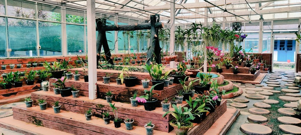
- The Glasshouse Orchidarium: A massive controlled-microclimate conservatory with a central spray fountain and fiberglass roof, displaying over 10,000 individual orchid plants representing more than 500 species. Visitors walk among hanging wooden baskets draped with cascades of epiphytic blooms, including translucent-white Coelogyne, golden-tasseled Dendrobium densiflorum, and vibrant violet Vanda coerulea (Blue Vanda).
- Tissue Culture & Micropropagation Laboratory: Because wild orchid seeds are microscopic and lack natural nutrient endosperm, they fail to germinate in the wild without a symbiotic mycorrhizal fungus. Inside Tipi's sterile laboratories, scientists cultivate orchid seeds on nutrient-rich agar media in glass flasks, producing 20,000 to 40,000 vigorous seedlings annually for reintroduction into the wild and distribution to local floriculturists.
- Rare & Keystone Species: Tipi safeguards critically endangered species including the legendary Lost Lady's Slipper Orchid (Paphiopedilum fairrieanum), Paphiopedilum venustum, Renanthera imschootiana (Red Vanda), Cymbidium eburneum, and Bulbophyllum.
- Sessa Orchid Sanctuary Connection: Located 24 km north along NH13, the 100 sq km Sessa Orchid Sanctuary acts as the in-situ natural reserve where wild orchids thrive across deep limestone gorges, tree-fern ravines, and mist-laden trekking trails overseen by Tipi's research scientists.
Kameng River Adventure & White-Water Rafting Logistics
The powerful, crystal-clear Kameng River makes Bhalukpong one of the finest white-water adventure hubs in Eastern India. Flowing through boulder-strewn canyon gorges framed by pristine rainforests, the river offers thrilling rafting runs ranging from beginner-friendly floats to technical multi-day expeditions:
- Day Rafting Runs (Grade II to III): The classic 12 km to 18 km rafting stretch between Tipi, Bhalukpong, and Potasali (Assam border) is ideal for beginners, families, and adventure enthusiasts. Guided by certified river marshals, rafters navigate roaring wave trains, bouncy roller-coasters, and gentle eddy pools over a 2 to 3-hour run.
- Multi-Day Wilderness Expeditions (Grade III to IV+): Advanced expeditioners embark on 4 to 6-day self-contained river runs starting upstream at Seppa, navigating high-volume canyon rapids and camping on virgin white-sand riverbanks beneath star-lit Himalayan skies.
- Rafting Seasonality: The official rafting season operates from October 1 to April 30, when post-monsoon river levels stabilize and water clarity transforms into an emerald-turquoise shade. Rafting is strictly closed during the high-turbidity monsoon flood months (May to September).
- Sport Angling & Golden Mahseer Conservation: The Kameng and Jia Bhoroli rivers are world-renowned habitats for the mighty Golden Mahseer (Tor putitora) and Chocolate Mahseer (Neolissochilus hexagonolepis). Angling is conducted strictly under a Catch-and-Release conservation policy in partnership with local community watch associations, ensuring the protection of critical breeding pools and aquatic ecosystems.
Trans-Boundary Wildlife Corridors & Hornbill Sanctuaries
Bhalukpong occupies a globally significant ecological position at the intersection of two contiguous, world-class protected areas:
- Pakke Tiger Reserve (Pakhui): Located 20 km to 30 km east in Pakke-Kessang district, Pakke covers 862 square kilometers of lowland semi-evergreen rainforest. It is internationally renowned for the community-driven Hornbill Nest Adoption Program, where indigenous Nyishi nest protectors safeguard the nesting cavities of four magnificent hornbill species: the Great Indian Hornbill, Wreathed Hornbill, Oriental Pied Hornbill, and the vulnerable Rufous-necked Hornbill. Pakke also shelters Bengal tigers, Asian elephants, clouded leopards, and over 300 butterfly species.
- Nameri National Park (Assam): Situated 20 km south across the Assam border, Nameri spans 200 square kilometers of sub-Himalayan alluvial grasslands and riverine semi-evergreen forests. Nameri is celebrated for guided walking nature safaris and provides a vital refuge for the endangered White-winged Wood Duck (Asarcornis scutulata)—the state bird of Assam—alongside herds of wild Asian elephants and capped langurs.
Together, these contiguous protected zones form an uninterrupted 1,000+ square kilometer trans-boundary wildlife corridor, making Bhalukpong the premier logistical base for naturalists, wildlife photographers, and birding enthusiasts.
How to Reach & Transit Logistics
Bhalukpong boasts excellent connectivity via modern highway and railway infrastructure:
- By Air: Tezpur Airport (TEZ) in Assam is the closest airport, located 52 km south (1.2 to 1.5 hours drive) with scheduled regional flights. Guwahati Lokpriya Gopinath Bordoloi International Airport (GAU), located 220–240 km away (4.5 to 5.5 hours drive), is the premier aviation gateway with daily non-stop flights from Delhi, Mumbai, Kolkata, and Bengaluru. Donyi Polo Airport (HGI) in Itanagar lies 160 km east (4 hours drive).
- By Rail: Bhalukpong Railway Station (BHNG) provides passenger rail links to Dekargaon and Rangapara North. Rangapara North Junction (RPAN), situated 45 km south (1 hour drive), is the major broad-gauge railhead connecting to Delhi, Kolkata, and Guwahati via superfast express trains like the Kamrup Express and Arunachal AC Superfast Express.
- By Road & The Nechiphu Tunnel: Bhalukpong is accessed via the smooth Balipara–Chariduar–Tawang (BCT) Highway (NH13). The drive from Guwahati (220 km) follows the 4-lane NH27 expressway past Nagaon and across the Brahmaputra via Kaliabhumur Bridge to Tezpur/Balipara. Uphill transit towards Bomdila (97 km / 3.5 hours), Dirang (140 km / 4.5–5 hours), and Tawang (275 km / 8–10 hours) has been revolutionized by the 500-meter Nechiphu Tunnel at 5,700 feet altitude (constructed by BRO Project Vartak), completely bypassing the dangerous Nechiphu fog-belt and landslide curves.
Local Food Culture & Traditional Culinary Practices
Dining in Bhalukpong represents a wholesome, aromatic fusion of indigenous Arunachali tribal recipes and traditional Assamese riverside flavors, emphasizing organic forest ingredients, naturally fermented shoots, and fresh river catch:
- Wood-Smoked Pork with Bastenga: Tender wood-smoked pork slow-cooked with Bastenga (naturally fermented shredded bamboo shoot), wild mountain ginger, garlic, and fresh green chilies, creating a savory, earthy, and aromatic broth.
- Charred River Fish in Banana Leaf: Freshly caught fish from the Kameng River rubbed with crushed wild coriander, bird's-eye chilies, and garlic, wrapped tightly in plantain leaves and slow-roasted over wood embers.
- Boiled Forest Greens & Fiddlehead Ferns: Tender wild fiddlehead ferns (Dhekia), stinging nettle broth, and garden squash simmered with minimal rock salt, wild ginger, and green chilies for a deeply nourishing, cleansing meal.
- Traditional Assamese Thali: Highway dhabas and local eateries serve comforting Assamese thalis featuring aromatic Joha rice, yellow pigeon pea lentils, Khar (alkaline plantain ash preparation), seasonal vegetable stir-fry, and Masor Tenga (light, tangy river fish curry with Assam lemon).
- Pona & Opo: Mild, naturally fermented traditional rice beverages brewed in tribal homes and offered in hand-carved bamboo tumblers during festivals and family celebrations.
Practical Travel Guide (The Honest Guide)
To ensure a seamless and rewarding journey through Bhalukpong, travelers should keep these grounded field realities in mind:
- Mandatory Inner Line Permit (ILP) Verification: All domestic Indian citizens must possess a valid Inner Line Permit (ILP) before arriving at the border (apply online at arunachalilp.com). All vehicles must halt at the Bhalukpong Border Check Post, where police strictly verify printed physical paper copies of your e-ILP and original government photo IDs (Aadhaar, Voter ID, Passport). Digital phone screen copies are not accepted for registration.
- Foreign National Regulations: Foreign travelers require a Protected Area Permit (PAP) issued by the Ministry of Home Affairs or Resident Commissioner offices, and must travel in groups of two or more through authorized local tour operators.
- Cash & ATM Availability: While Bhalukpong town has 2–3 ATMs (SBI and Apex Bank), they frequently run dry or experience communication fiber outages. Carry ₹5,000 to ₹10,000 in physical cash withdrawn in Tezpur or Balipara for homestay bills, rafting charges, and local dining.
- Mobile Connectivity: Strong 4G LTE coverage on Jio and Airtel is available throughout Bhalukpong town and riverside resorts. However, mobile reception drops to zero inside deep river gorges toward Tipi and Sessa. BSNL provides basic voice fallback.
- Fuel Replenishment: Bhalukpong features two operational fuel outlets (Indian Oil / Assam Oil) along the highway. Always top off your fuel tank here before ascending towards Bomdila, as steep mountain gradients increase fuel consumption and the next major fuel stations are 95 km uphill in Rupa and Bomdila.
- Power Grid Realities: Heavy subtropical rainstorms can trigger temporary local power cuts; reputable riverside eco-resorts maintain dedicated diesel generator (DG) backups.
Bhalukpong is part of the breathtaking Northeast India region, known for its pristine natural beauty, rich tribal culture, and unique biodiversity.
TRAVEL PLANNING
Plan Your Visit
Essential guides to prepare for your trip
Itineraries & Trips
Curated 3-day, 5-day & 7-day trip routes
Places to Visit
Top waterfalls, viewpoints & landmarks
Best Time to Visit
When to go for the best experience
How to Reach
Flights, trains, taxis and road options
Where to Stay
Homestays, eco-lodges & resorts
Permits & Entry
Required documents and ILP pass guidance
Bhalukpong Tour Packages
Ready-to-book Bhalukpong tours

Need a Custom Plan?
As Northeast India locals, we work directly with our trusted community drivers and homestay hosts.
Talk to an ExpertTOP ATTRACTIONS
Places to Visit in Bhalukpong
Must-see attractions and hidden gems across Bhalukpong

- Orchid Research Centre, Tippi: Exploring Asia's premier orchid sanctuary and tissue culture research hub on the Kameng River
How Many Days in Bhalukpong?
Plan your own route — or let us handle everything
Things to Do in Bhalukpong
Curated experiences and activities across Bhalukpong by local experts
Where to Stay in Bhalukpong
Verified stays in Bhalukpong with local character
Getting Around
Safe, reliable transfers and car hire in Bhalukpong
Practical Travel Realities & Local Tips
Terrain, ground rules, and essential preparation for Bhalukpong
Bhalukpong is an Easy to Moderate destination, situated at a low foothill elevation of 213 meters (699 feet). There is zero risk of High Altitude Sickness (AMS), making it an ideal acclimatization stop before ascending the steep 3,048-meter passes toward Tawang.
Physical Accessibility: Bhalukpong market, riverside resorts, and the Tipi Orchidarium feature flat, paved walking paths accessible to travelers of all age groups, including elderly visitors and families with young children. Bhalukpong Fort ruins require a gentle 15-minute walk over unpaved earthen trails.
Adventure Exertion: White-water rafting on the Kameng River is graded Class II to III around Bhalukpong, suitable for beginners with standard safety lifejackets and certified river guides. Nature walking safaris across the border in Nameri involve 5–10 km of flat forest hiking.
Local Culinary Traditions & Food
Authentic indigenous gastronomy, tribal flavours, and culinary culture in Bhalukpong
Dining in Bhalukpong reflects an authentic harmony between indigenous Arunachali tribal traditions (Aka and Nyishi) and traditional Assamese riverside cuisine, emphasizing fresh forest herbs, organic bamboo shoots, and freshly caught river fish.
Indigenous Tribal Specialties:
- Smoked Meat with Bastenga: Wood-smoked pork or chicken slow-simmered with naturally fermented bamboo shoot (Bastenga), wild mountain ginger, garlic, and fresh green herbs.
- Charred River Fish: Freshly caught fish from the Kameng River seasoned with crushed local spices, wrapped tightly in wild plantain leaves, and wood-roasted over open embers.
- Boiled Forest Greens & Squash: Tender wild fiddlehead ferns (Dhekia), stinging nettle broth, and indigenous mountain squash simmered with minimal rock salt and green chilies.
- Pona / Opo: Mild, traditional fermented rice beverage brewed in tribal homes and served in carved bamboo tumblers during festivals and celebratory meals.
Assamese & Regional Cuisine:
- Assamese Thali: Wholesome spreads of aromatic Joha rice, yellow lentils, Khar (alkaline preparation filtered through banana peel ash), seasonal vegetable fry, and Masor Tenga (light, tangy river fish curry flavored with Assam lemon).
- Dhaba Classics: Highway eateries along the BCT road serve fresh tawa rotis, country chicken curries, dal tadka, and hot ginger-cardamom tea.
Combine Bhalukpong With
Extend your trip with nearby destinations
Travel Guides
Expert guides for Bhalukpong
Reviews
"Nezo Tours organized our fantastic trip. The team was attentive and flexible, accommodating last-minute changes to suit our needs."
Yamini Peter
Mumbai, Maharashtra
"We got the best service than expected. The guide was very friendly and very very helpful, throughout our journey he guided us."
Ammiel Shabong
Shillong, Meghalaya
"Service was excellent. Prices were the best compared to those offered by others. All in all a satisfying experience. Definitely recommended."
Pradeep Agarwal
Delhi, India
PLAN YOUR TRIP
FAQs
Can't find the answer you're looking for? Our expert travel team is always on hand to help you plan the perfect Bhalukpong experience.
Ready to Explore Bhalukpong?
Let our local experts help you plan the perfect trip. Get personalized recommendations and instant quotes.