
Bomdila (Bomdila Town)
Updated 2026West Kameng Headquarters, Tibetan Monastic Citadels & Eastern Himalayan Vistas
| Category | Detail |
|---|---|
| Altitude / Elevation | 2,217 meters (7,274 ft) |
| Coordinates | 27.265° N, 92.416° E |
| District | West Kameng District (Headquarters) |
| Gompas Count | 3 Distinct Monasteries (Upper, Middle, and Lower Gompas) |
| Highest Peaks Viewed | Kangto (7,090m) & Gorichen (6,488m) |
| Horticulture | Apple Orchards, Kiwi Plantations & State Orchidarium at Tipi (lower elevation) |
| Major Monastery | Gontse Gaden Rabgyel Lhing (Upper Gompa, founded 1965 by 12th Tsona Gontse Rinpoche) |
| Permit Mandate | ILP mandatory for Indian tourists (eilp.arunachal.gov.in or arunachalilp.com); PAP for foreigners |
| Wildlife Gateway | Eaglenest Wildlife Sanctuary (Bugun Liocichla habitat) |
Bomdila is a mountain ridge town and administrative headquarters of the West Kameng district, situated at 2,217 meters (7,274 feet) in western Arunachal Pradesh. Renowned for its three tiered Buddhist monasteries—anchored by the 1965 Gontse Gaden Rabgyel Lhing (Upper Gompa)—sweeping panoramas of Mount Kangto (7,090m), and proximity to the Eaglenest Wildlife Sanctuary, it serves as a critical highland cultural hub.
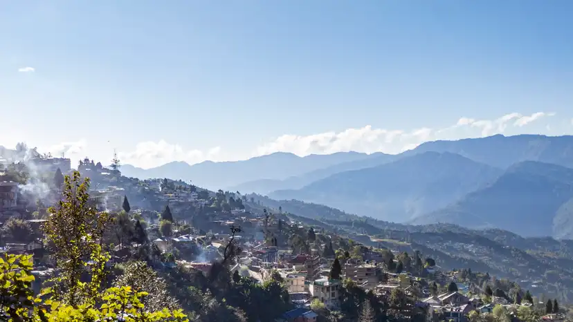
Cold mountain winds whip across the high ridge, carrying the sharp scent of Himalayan blue pine and burning incense from the upper monastery. Below, the terraced roofs and apple orchards of Bomdila cling to steep green slopes, while on clear mornings, the jagged snow massifs of Kangto and Gorichen gleam white against a cobalt sky. Inside the prayer hall, young monks chant rhythmic Gelugpa verses amidst flickering butter lamps.
Inner Line Permit (ILP) is mandatory for domestic Indian nationals entering Arunachal Pradesh (eILP portal: eilp.arunachal.gov.in or arunachalilp.com: fee ₹300 up to 3 days, ₹500 beyond 3 days up to 14 days). Foreign travelers require a Protected Area Permit (PAP, US$ 50) issued to groups of two or more.
Geography, Ridge Topography & Mountain Panoramas
Bomdila is a prominent highland ridge town and the administrative headquarters of the West Kameng district, situated at an altitude of 2,217 meters (7,274 feet) above sea level in western Arunachal Pradesh. Located 150 km north of Tezpur and 175 km south of Tawang along the Trans-Arunachal Highway corridor, Bomdila clings to the steep, pine-cloaked contours of the Lesser Himalayas overlooking the deep, forested valley of the Kameng River.
The town's topography is characterized by precipitous slopes, terraced hillside settlements, and high vantage points that provide some of the most dramatic mountain vistas in the Eastern Himalayas. On crisp, cloudless mornings during autumn and winter, the high ridges of Bomdila offer an extraordinary line-of-sight view of the glaciated Great Himalayan peaks along the northern horizon, dominated by the formidable summit of Mount Kangto (7,090 meters / 23,261 feet)—the highest peak in Arunachal Pradesh—and the glaciated pyramid of Mount Gorichen (6,488 meters).
The climate of Bomdila is classified as subtropical highland (Cwb), moderated by its high elevation. Summers (April to June) are cool and refreshing, with daytime temperatures fluctuating between 14°C and 22°C. Winters (November to February) bring biting alpine winds and frost, with night temperatures dropping between -2°C and 6°C. The southwest monsoon deposits between 1,400 and 1,700 mm of rainfall between June and August, frequently shrouding the mountain ridges in dense fog and mountain mists.
The Three Monastic Citadels: Upper, Middle & Lower Gompas
Bomdila's spiritual and architectural landscape is anchored by three prominent Buddhist monasteries belonging to the Gelugpa and Mahayana traditions, historically situated across three distinct elevations of the town:
- Gontse Gaden Rabgyel Lhing (Upper Gompa): The premier monastic institution of West Kameng, situated on a high promontory 3 km above the main town. Founded in 1965 by the 12th Tsona Gontse Rinpoche, the Upper Gompa was built as a spiritual reincarnation of the historic Tsona Gontse Monastery in southern Tibet. The main prayer hall (Dukhang) houses a towering gilded statue of the Buddha, surrounded by intricately painted thangkas and statues of the bodhisattvas. The complex includes a massive ceremonial prayer wheel, a dedicated school for young novice monks, and a quiet stupa garden overlooking the entire valley basin.
- The Middle Gompa (Blue Gompa): Located near the central market area, this monastery is one of the oldest spiritual centers in Bomdila. It is celebrated for its traditional Tibetan medical clinic, ancient printing blocks, and vibrant murals depicting the Buddhist Wheel of Life (Bhavacakra).
- The Lower Gompa: Situated at the base of the town near the commercial hub, the Lower Gompa features a large, beautifully decorated prayer hall with a traditional courtyard where community Buddhist festivals, prayer flag consecrations, and Losar celebrations take place.
Together, these three gompas form an active spiritual circuit where the sound of chanting, deep bass dungchen horns, and spinning brass prayer wheels form the daily rhythm of life.
Apple Orchards, Craft Centres & Ethnographic Heritage
Bomdila is an important center for indigenous handicraft preservation, regional trade, and highland horticulture:
- District Craft Centre & Industrial Training Institute: Located near the town center, this government-established heritage complex preserves traditional Monpa and Sherdukpen artisanal skills. Visitors can watch local artisans weave intricate dragon-motif woolen carpets (Dan), carve ceremonial wooden masks and tables (Choktse), and weave traditional handloom textiles using backstrap and frame looms. The attached emporium offers authenticated hand-woven shawls, thangkas, and handcrafted bamboo goods directly from local cooperatives.
- Horticulture Farms & Apple Orchards: The slopes surrounding Bomdila are terraced with government-managed horticulture research farms and private apple orchards. During spring (March–April), the hillsides are covered in white and pink apple blossoms, while autumn (September–October) brings branches heavy with ripe apples, pears, and plums.
- Ethnographic Diversity: As the administrative capital of West Kameng, Bomdila represents a vibrant cultural melting pot where the Monpa, Sherdukpen, Miji (Sajolang), Bugun (Khowa), and Hrusso (Aka) communities interact in daily commerce, displaying distinct traditional attire, bead jewelry, and cultural customs in the bustling main bazaar.
Gateway to Eaglenest Wildlife Sanctuary
Bomdila serves as the primary administrative and logistical staging base for birdwatching and wildlife expeditions into the world-renowned Eaglenest Wildlife Sanctuary, located approximately 45 km to the southwest in the West Kameng foothills.
Spanning an extreme elevational gradient from 500 meters to 3,250 meters, Eaglenest is globally celebrated as one of the most critical biodiversity hotspots on the planet:
- The Bugun Liocichla Discovery: Eaglenest achieved international fame in 2006 when professional astronomer and birdwatcher Dr. Ramana Athreya discovered a completely new, brightly colored avian species—the Bugun Liocichla (Liocichla bugunorum)—described from Lama Camp within the sanctuary. It was the first new bird species discovered in mainland India in over fifty years.
- Avian Diversity: The sanctuary harbors over 500 bird species, including the Ward's Trogon, Blyth's Tragopan, Beautiful Nuthatch, Rufous-necked Hornbill, and Chestnut-breasted Hill Partridge, attracting ornithologists and wildlife photographers from around the globe.
- Mammalian Fauna: The dense sub-tropical and temperate forests of Eaglenest protect endangered mammalian species including the Red Panda, Clouded Leopard, Asian Elephant, Himalayan Black Bear, and the elusive Arunachal Macaque (Macaca munzala).
Local Food Culture & Mountain Produce
Dining in Bomdila features hearty Himalayan comfort dishes tailored to cold mountain evenings:
- Thukpa: Steaming bowls of hand-pulled wheat noodles simmered in rich bone or vegetable broth with sliced mountain greens, ginger, garlic, and shredded meat.
- Momos: Fresh steamed dumplings stuffed with seasoned minced pork, chicken, or local organic cabbage and grated cheese, served with spicy fire-roasted chili sauce.
- Zan: A dense, traditional porridge made by stirring roasted millet or barley flour into boiling water, accompanied by cooked seasonal vegetables and meat stews.
- Gyapa Khazi: Savory fried rice cooked with fermented dried yak cheese (Chhurpi), diced mountain potatoes, and mild spices.
- Chhurpi Soup: A pungent, warming stew made from sun-dried cheese cubes simmered with dried whole red chilies, garlic, and fresh coriander.
- Local Fruit Beverages: Fresh apple cider, fermented fruit wines, and traditional butter tea (Suja) served hot in local cafes.
Transit Logistics & Ridge Route Planning
Bomdila is strategically located along the primary access artery into western Arunachal Pradesh:
- Highway Corridor: The standard overland approach begins at Guwahati (265 km / 6–8 hours) or Tezpur (150 km / 3.5–4.5 hours) in Assam. Travelers cross the Arunachal border at Bhalukpong, pass through the orchid sanctuary at Tipi and the sub-tropical gorges of Sessa, navigate the modern Nechiphu Tunnel (500 meters), and climb steadily up to the Bomdila ridge at 2,217 meters.
- Route Choices to Tawang: From Bomdila, travelers can either continue descending into the Dirang Valley (40 km / 1.5 hours) along the main highway toward the Sela Tunnel and Tawang, or take the scenic mountain loop via Rupa and the Sherdukpen heartland.
- Road Conditions: The highway between Bhalukpong and Bomdila has been significantly widened and upgraded under the Trans-Arunachal Highway project, featuring smooth asphalt and reinforced retaining walls, though monsoon rains (June–August) can trigger occasional rockfalls near Sessa.
Practical Travel Guide (The Honest Guide)
Travelers visiting Bomdila should keep several practical considerations in mind:
- Permit Protocols (ILP & PAP): Domestic Indian tourists must carry an approved Inner Line Permit (ILP) obtained online through
eilp.arunachal.gov.inorarunachalilp.com(fee: ₹300 up to 3 days, ₹500 beyond 3 days up to 14 days). Present physical paper copies at the Bhalukpong border checkpost. Foreign nationals require a Protected Area Permit (PAP) obtained for groups of two or more via registered operators. - Altitude & Weather Precautions: At 2,217 meters, Bomdila can feel noticeably cold, especially when evening mountain mists roll over the ridge. Pack layered thermal clothing, fleece jackets, and windproof outer shells even during spring and autumn.
- Financial Facilities: As the district headquarters, Bomdila possesses numerous operational ATMs (SBI, Axis Bank, HDFC) and banks along the main market road. Digital UPI transactions are widely accepted in hotels and retail shops, though carrying ₹3,000 to ₹5,000 in cash is recommended for small craft stalls and rural detours.
- Connectivity: Jio, Airtel, and BSNL provide dependable 4G and 5G cellular network coverage and mobile internet across Bomdila town.
Bomdila is part of the breathtaking Northeast India region, known for its pristine natural beauty, rich tribal culture, and unique biodiversity.
TRAVEL PLANNING
Plan Your Visit
Essential guides to prepare for your trip
Itineraries & Trips
Curated 3-day, 5-day & 7-day trip routes
Places to Visit
Top waterfalls, viewpoints & landmarks
Best Time to Visit
When to go for the best experience
How to Reach
Flights, trains, taxis and road options
Where to Stay
Homestays, eco-lodges & resorts
Permits & Entry
Required documents and ILP pass guidance
Bomdila Tour Packages
Ready-to-book Bomdila tours


Need a Custom Plan?
As Northeast India locals, we work directly with our trusted community drivers and homestay hosts.
Talk to an ExpertTOP ATTRACTIONS
Places to Visit in Bomdila
Must-see attractions and hidden gems across Bomdila

- Bomdila Monastery: Gentse Gaden Rabgyel Lling - Majestic three-level citadel overlooking Bomdila
How Many Days in Bomdila?
Plan your own route — or let us handle everything
Things to Do in Bomdila
Curated experiences and activities across Bomdila by local experts
Where to Stay in Bomdila
Verified stays in Bomdila with local character


Getting Around
Safe, reliable transfers and car hire in Bomdila
Practical Travel Realities & Local Tips
Terrain, ground rules, and essential preparation for Bomdila
Bomdila is classified as an Easy to Moderate Himalayan destination, suitable for travelers of all ages with basic mobility:
- Altitude Profile (2,415 m / 7,923 ft): Moderate elevation. Most travelers experience no severe altitude symptoms, making Bomdila the perfect stepping stone before ascending to Sela Pass (4,170 m) and Tawang (3,048 m).
- Walking & Terrain: The town is built across sloping hillside terraces. Exploring the Upper Gompa involves climbing gentle flights of stone stairs. The Crafts Centre, Lower Gompa, and local bazaar are easily walkable.
- Road Journey: The 7.5 to 8.5-hour drive from Guwahati traverses over 150 hairpin bends. Travelers prone to motion sickness should carry appropriate medication.
- Accessibility for Seniors & Children: Highly accessible. Vehicles can drop passengers directly at the main gate of the Upper Gompa, Crafts Centre, and RR Hill viewpoint without long trekking requirements.
Local Culinary Traditions & Food
Authentic indigenous gastronomy, tribal flavours, and culinary culture in Bomdila
The food culture of Bomdila is a hearty mountain cuisine shaped by high-altitude Monpa traditions, Tibetan culinary heritage, and fertile temperate organic farms:
Traditional Dishes to Try
- Zan: The quintessential Monpa comfort staple. A wholesome porridge made from roasted finger millet or buckwheat flour stirred into boiling water, served hot with sautéed wild forest greens, dried meat, or spicy chili paste.
- Momos & Tingmo: Steamed Tibetan dumplings filled with seasoned pork, minced chicken, or local highland cabbage and fresh cheese, accompanied by fiery red chili-garlic chutney. Tingmo is soft, steamed layered bread ideal for soaking up rich broths.
- Thukpa & Gyathuk: Steaming bowls of hand-pulled noodles in a fragrant, clear bone or vegetable broth infused with mountain herbs, ginger, garlic, and fresh greens.
- Gyapa Khazi: A festive Monpa spiced rice specialty cooked with crumbled fermented yak cheese (Churpi), sun-dried river fish, wild chilies, fresh ginger, and rich local butter.
- Lukter: Sun-dried cooked beef or pork flakes mixed with crushed ghost chilies (Bhut Jolokia) and local Sichuan pepper (timmur), eaten as a pungent side dish.
- Churpi & Chamin: Fermented yak or cow cheese. Fresh soft churpi is simmered with chilies into a spicy dipping sauce (Chamin), while hard smoked churpi is chewed during journeys.
- Po Cha (Butter Tea) & Sweet Milk Tea: Traditional Tibetan butter tea churned with fermented yak butter, salt, and black tea leaves, providing essential warmth and preventing altitude chapping.
- Fresh Apples & Organic Kiwi: West Kameng is the fruit basket of Arunachal Pradesh. In autumn, sample crisp golden and red apples, organic kiwi fruit, and locally fermented apple cider.
Combine Bomdila With
Extend your trip with nearby destinations
Travel Guides
Expert guides for Bomdila
Reviews
"Nezo Tours organized our fantastic trip. The team was attentive and flexible, accommodating last-minute changes to suit our needs."
Yamini Peter
Mumbai, Maharashtra
"We got the best service than expected. The guide was very friendly and very very helpful, throughout our journey he guided us."
Ammiel Shabong
Shillong, Meghalaya
"Service was excellent. Prices were the best compared to those offered by others. All in all a satisfying experience. Definitely recommended."
Pradeep Agarwal
Delhi, India
PLAN YOUR TRIP
FAQs
Can't find the answer you're looking for? Our expert travel team is always on hand to help you plan the perfect Bomdila experience.
Ready to Explore Bomdila?
Let our local experts help you plan the perfect trip. Get personalized recommendations and instant quotes.